Topography Quote: Template, Model and PDF Example
Need to create a quote now?
Generate professional quotes in less than 2 minutes with our AI-powered tool.
Quoting topography services requires clearly specifying the type of survey, the equipment to be used and the deliverables. Every project is unique and costs depend on the terrain, the location and the required precision.
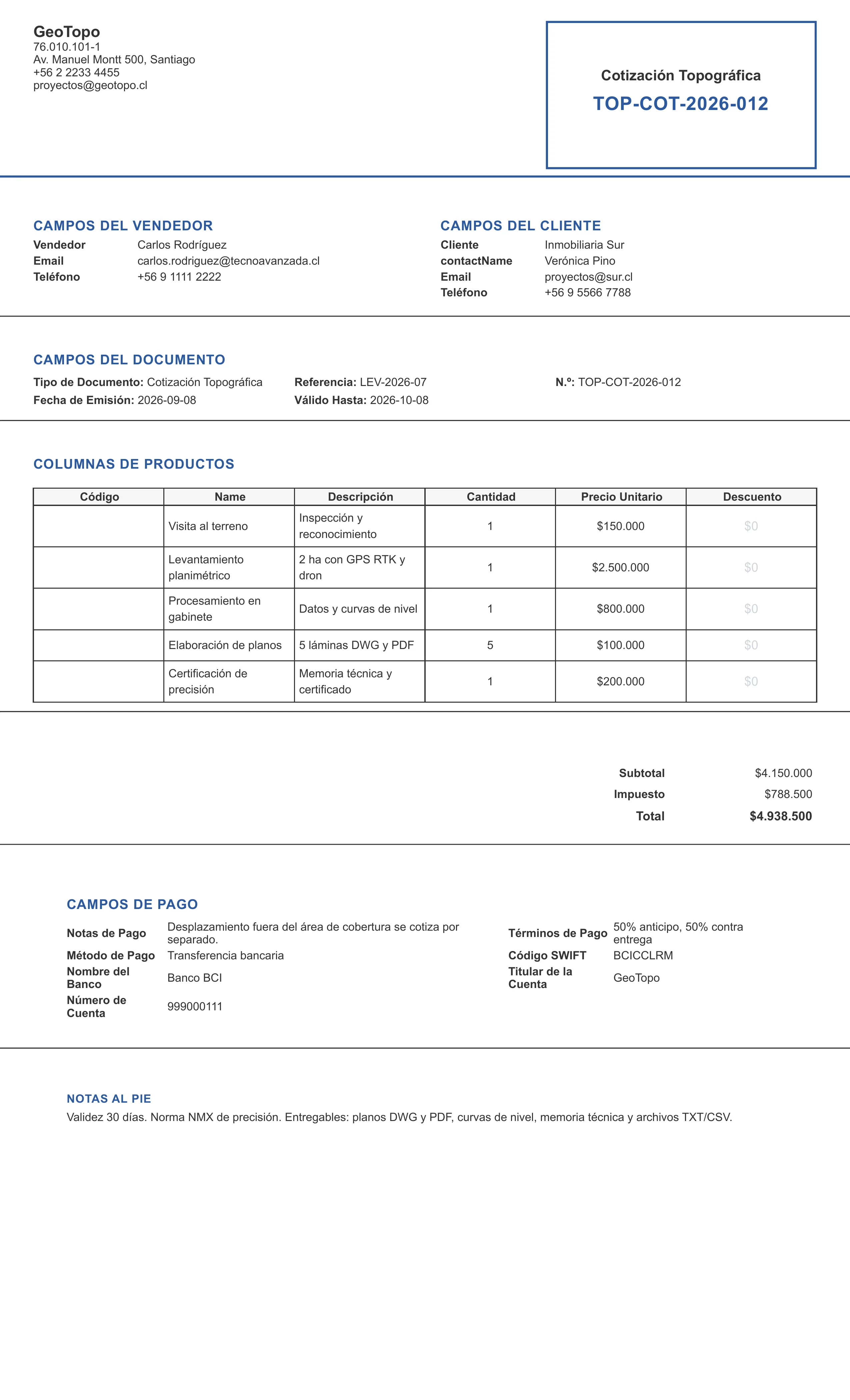
Topography quote generated with the system
This is what a topography survey quote looks like when created with our generator: surveyor and client data, the equipment and area breakdown and the price, ready to send to your client.
Structure of a topography quote
Project data
Project name, terrain location, type of survey (topographic, planimetric, altimetric, GPS), area to cover (hectares or square meters), and the purpose of the survey.
Equipment and methods
Specify which equipment will be used and why it is suitable for the project:
- Total station (2-5 mm precision)
- Differential GPS / RTK
- Drone with photogrammetry
- Precision level
Required staff
| Role | Quantity |
|---|---|
| Professional surveyor | 1 |
| Chainman / assistant | 2 |
| Drone operator (if applicable) | 1 |
Deliverables
- Topographic plans in DWG and PDF format
- Contour lines every 0.5 m or 1 m
- Technical report of the survey
- Point files in TXT/CSV format
- Precision certification
Budget example
| Item | Quantity | Price |
|---|---|---|
| Site visit | 1 | $150,000 |
| Planimetric survey (2 ha) | 1 | $2,500,000 |
| Data processing in the office | 1 | $800,000 |
| Plan drafting | 5 sheets | $500,000 |
| Precision certification | 1 | $200,000 |
| Total | $4,150,000 |
Terms
Quote validity (30 days), payment method (50% deposit, 50% on delivery), execution timeline, late penalties (if applicable) and weather conditions that could affect the schedule.
Tips for quoting topography
- Visit the terrain always before quoting — topography depends heavily on accessibility
- Specify the standard of precision you will apply (NMX, ISO, etc.)
- Include travel costs if the terrain is outside your coverage area
- Define clear deliverables: plans in which format, scales, levels of detail
- Add exclusions: clearing, removal of dense vegetation, access permits
Create your professional topography quote
Use our generator to create professional topographic service quotes in minutes.
Frequently asked questions
How do I make a topography quote?
To make a topography quote, include: the surveyor's or company's data, a description of the terrain or project, the type of survey (planimetric, altimetric, GPS), the area to cover, the equipment to be used, the required staff, data processing, delivery time and payment terms.
What should I include in a topographic survey quote?
It should include: a site visit, the type of survey (topographic, planimetric, altimetric, tacheometric), the area in hectares or square meters, the number of points, the equipment (total station, GPS, drone), the staff (surveyor, chainman, assistant), office processing, plans and certifications.
How much does a topographic survey cost?
The cost of a topographic survey varies with the size of the terrain, the complexity of the relief, the equipment needed and the location. It is typically quoted per hectare, per hour or per project. A basic survey of 1 ha can cost between $500 and $2,000 depending on the region.